A river is a large, natural stream of flowing water. Rivers are found on every continent and on nearly every kind of land. Some flow all year round. Others flow seasonally or during wet years. A river may be only kilometers long or it may span much of a continent.
The longest rivers in the world are the Nile in Africa and the Amazon in South America. Both rivers flow through many countries. For centuries, scientists have debated which river is longer. Measuring a river is difficult because it is hard to pinpoint its exact beginning and end. Also, the length of rivers can change as they meander, are dammed, or their deltas grow and recede.
The Amazon is estimated to be between 6,259 kilometers (3,903 miles) and 6,800 kilometers (4,225 miles) long. The Nile is estimated to be between 5,499 kilometers (3,437 miles) and 6,690 kilometers (4,180 miles) long. There is no debate, however, that the Amazon carries more water than any other river on Earth. Approximately one-fifth of all the fresh water entering the oceans comes from the Amazon.
Rivers are important for many reasons. One of the most important things they do is carry large quantities of water from the land to the ocean. There, seawater constantly evaporates. The resulting water vapor forms clouds. Clouds carry moisture over land and release it as precipitation. This freshwater feeds rivers and smaller streams. The movement of water between land, ocean and air is called the water cycle. The water cycle constantly replenishes Earth’s supply of fresh water, which is essential for almost all living things.
Anatomy of a River
No two rivers are exactly alike. Yet all rivers have certain features in common and go through similar stages as they age.

The beginning of a river is called its source or headwaters. The source may be a melting glacier, such as the Gangotri Glacier, the source of the Ganges River in Asia. The source could be melting snow, such as the snows of the Andes, which feed the Amazon River. A river’s source could be a lake with an outflowing stream, such as Lake Itasca in the U.S. state of Minnesota, the source of the Mississippi River. A spring bubbling out of the ground can also be the headwaters of a river. The source of the Danube River is a spring in the Black Forest of Germany.
From its source, a river flows downhill as a small stream. Precipitation and groundwater add to the river’s flow. It is also fed by other streams, called tributaries. For instance, the Amazon River receives water from more than 1,000 tributaries. Together, a river and its tributaries make up a river system. A river system is also called a drainage basin or watershed. A river’s watershed includes the river, all its tributaries and any groundwater resources in the area.
The end of a river is its mouth. Here, the river empties into another body of water—a larger river, a lake or the ocean. Many of the largest rivers empty into the ocean.
The flowing water of a river has great power to carve and shape the landscape. Many landforms, like the Grand Canyon in the U.S. state of Arizona, were sculpted by rivers over time. This process is called weathering or erosion.
The energy of flowing river water comes from the force of gravity, which pulls the water downward. The steeper the slope of a river, the faster the river moves and the more energy it has.
The movement of water in a river is called a current. The current is usually strongest near the river’s source. Storms can also increase the current. A swift current can move even large boulders. These break apart, and the pieces that are carried in the moving water scrape and dig into the river bottom, or bed.
Little by little, a river tears away rocks and soil along its bed, and carries them downstream. The river carves a narrow, V-shaped valley. Rapids and waterfalls are common to rivers, particularly near their sources.

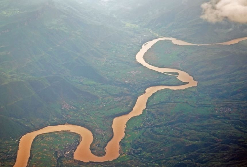
Eventually, the river flows to lower land. As the slope of its course flattens, the river cuts less deeply into its bed. Instead, it begins to wind from side to side in looping bends called meanders. This action widens the river valley.
At the same time, the river begins to leave behind some of the rocks, sand and other solid material it collected upstream. This material is called sediment. Once the sediment is deposited, it is called alluvium. Alluvium may contain a great deal of eroded topsoil from upstream and from the banks of its meanders. Because of this, a river deposits very fertile soil on its flood plain. A flood plain is the area next to the river that is subject to flooding.
The deepest part of a river bed is called a channel. The channel is usually located in the middle of a river. Here, the current is often strong. In large rivers, ships travel in channels. Engineers may dredge, or dig, deeper channels so more water can flow through the river or the river can transport larger ships.
Near the end of its journey, the river slows and may appear to move sluggishly. It has less energy to cut into the land and it can no longer carry a heavy load of sediment. Where the river meets the ocean or a lake, it may deposit so much sediment that new land, a delta, is formed.
Not all rivers have deltas. The Amazon does not have a true delta, for instance. The strength of the tides and currents of the Atlantic Ocean prevent the build-up of sediment. Deltas almost always have fertile soil. The Nile Delta and the Ganges Delta are the chief agricultural areas for Egypt and Bangladesh, for instance.